CMON 3D World Map.

supervike

Super Moderator
I\'m a little sad to say this...

Originally posted by vincegamer
@Vike I\'m glad I\'m not the only one looking for monuments.
Here\'s what\'s been stumping me:
They always say the Great Wall of China is the only man-made object visible from space. Well I sure as heck can\'t see it on any of these photos. While putting on the 3D and soaring over the mountains of China is fun, it\'s frustrating that I see no sign of the Wall.

-From your list I haven\'t seen the Eiffel Tower, the St. Louis Arch, or Mt Rushmore.
-I have seen the twin towers site.
-Off your list I\'ve seen the Great Pyramid at Gaza, the Bacillica of St. Peter in Rome, and the Louvre (medieval style building with ugly glass pyramid stuck in the center).

I \'know\' my way around Paris because of a goofy Video Game called Midtown Madness for the X-Box. It helped me know where to look for the Effel Tower, The Louvre, and the Arc D\' Triumph. It also has Washington D.C. on the game, so I know where to look for the major stuff there too....And my mom told me Video Games would never get me anywhere! LOL

I searched in vain too for the Great Wall, but the Pyramids never even occured to me!! So much Earth, so little time...lol
 

Etherion

New member
Originally posted by vincegamer

Or, we could start a new thread called Google Earth Tourism
Each entry must be the name of a cite and its coordinates.

Hey I support that. :D Go ahead and start one whenever you feel like it. I might even turn that information into a \"Hitchhikers guide to the Cmon Earthmap\" - file sometime. lol
 

vincegamer

New member
Has anyone else noticed that names of things aren\'t actually on the right place sometimes?

Machu Picchu is a few degrees away to the northwest of the word, and the word Sphynx is out in the Egyptian desert with nothing around it (still haven\'t been able to locate the actual sphynx)
 

No Such Agency

New member
Originally posted by Modderrhu
Originally posted by SaxonAngel
Really this is super cool. If I had the chance that it was real-time I\'d run out and moon the lot of you. :D
Right, which government do we speak to to budget for real-time satellite imaging? ???
At ten-centimeter resolution? Well, let\'s just say that They have the same initials as me and likely wouldn\'t even admit to (or deny) operating any spacecraft...
 

vincegamer

New member
Anyone know what is the most realistic elevation exageration?

I set it to 2 and it looks pretty good, but I\'m not sure if it\'s realistic, never having been to most of the mountains I\'m looking at.

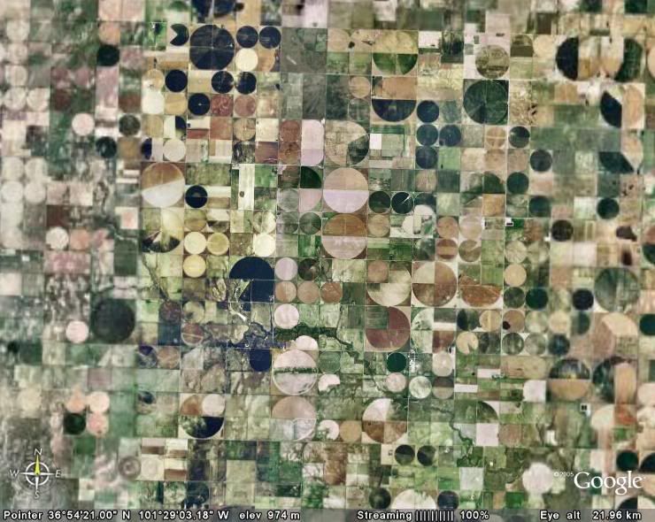
Now on a totally flat subject, no, this is not a quilt. This is the photo of the Oklahoma Panhandle (texas \"panhandle\" and much of Kansas looks just like this too)

Panhandle.jpg
 

dauber22

New member
Originally posted by No Such Agency
Originally posted by Modderrhu
Originally posted by SaxonAngel
Really this is super cool. If I had the chance that it was real-time I\'d run out and moon the lot of you. :D
Right, which government do we speak to to budget for real-time satellite imaging? ???
At ten-centimeter resolution? Well, let\'s just say that They have the same initials as me and likely wouldn\'t even admit to (or deny) operating any spacecraft...

So your saying that if we send you a large enough donation, you\'ll see to it that we get a satellite photo of Saxon Angerl mooning us ? :D Okay! What was that address again.???:D
 

vincegamer

New member
Lloyd,
Yes, exactly. The different colors I believe are different crops.
The irrigation is done with these big sprinkler things that are hinged on a spoke in the center and sweep a big circle around the field spraying water.
 

Talion

New member
Which places have 3d Buildings. I know the terrain is in 3D but not much else. The Eiffel Tower is flat.

I want 3D............:flame:
 

No Such Agency

New member
Originally posted by Talion
Which places have 3d Buildings. I know the terrain is in 3D but not much else. The Eiffel Tower is flat.

I want 3D............:flame:
Major US cities only. Fair warning that the building models view brings lesser computers to their knees...
 

vincegamer

New member
That\'s what I said:innocent:

Anyway....Talion, if you look in the lower left corner there is a box marked \"layers.\"
Look at the scroll down menu to \"3D Buildings.\" Click on the triangle, and it opens a list of all the cities for which there is 3D information.

By the way, that info is apparently limited to height, or at least has very little other info. For example, if you look at St. Louis Missouri, the arch is a big rectangular box! yet in NYC, the Empire State Building has it\'s characteristic pointy bit!

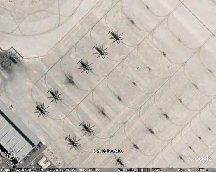
Now for more fun. I found this field of giant cockroaches in San Diego!

Sandiego.jpg


It\'s by an airport so I think they are helecopters. Might be a military base but I wouldn\'t know. Looked like bugs to me though!:D

I just noticed I used to live almost equidistant between EricJ and Leopardpixi. If only I\'d known:(
 

Galante

New member
I might not be able to install the program, but I can still search for my house on the site, and here it is:
93e4f1f5.jpg


This tool is amazing.
 

minimaker

New member
Can\'t install the program yet but did have a look at the google map site. Unfortunately my town is in one of the hazy undetailed areas. Found it through. :)
Does the google earth program use the same satelite photos as the map site does?
 

MarkusTay

New member
Still having problems with the download, gonna have to try using that freeware unzipper Paolo mentioned. Anyway, this Google thing is cool, but a bit scarey...

Myhouse1.jpg


And this technology is several years old...

Now I know how we put a missile through Khadafy\'s bedroom window from seven miles away... lol
 

philologus

Subgenius
@Etherion:

@philo seems you live a bit out in the green now.


Yes, I live just far enough away from Atlanta to put me into lower resolution. However you can see my subdivision and my cul-de-sac.
 

Etherion

New member
@Markus. Oh man, Thats Long Island? Darned I was off again by some miles. :eek: About the file: you actually do not need to unzip it. Just start Googleearth then choose \"file\" -> \"open\" and select the downloaded file Cmon1_5.kmz. (As stated by duende in other thread) Maybe we had a mixup about the issue, the file is not zipped or compressed.

@Steelcult: ya mean this:

steel.jpg

:eek:

@Philo:
Quote: However you can see my subdivision and my cul-de-sac.

Man whatever that means, I am sure its nasty, you perv!
lol

@Minimaker: Yes It uses the same satellite images.
 
Back To Top
Top